Florida Tour Day 2 – DeLand to St. Augustine
4:00 AM. Gotta pee. Stumbling around the campsite in a state of half-sleep. Suddenly, all thoughts of sleep are gone! Yes, that was definitely the rumble of thunder you just heard. Quick! Check the radar. Yep, it looks nasty and it’s moving toward you fast! Holy crap! That’s not in the plan this morning!
My first inclination was to just huddle down in the tent and wait it out, but the more I thought about it, the less I liked that idea. To wait it out would mean that I would have to pack up a very wet tent, and carry it around all day. I’ve done that before, and I swear it adds about 10 pounds to your load. Besides…I knew I wasn’t going to get any more sleep. By my calculation, it would be more pleasant to hurry up and get packed up, then wait out the storm on the porch again before heading out to breakfast. So, that’s what I did.

So, there I was. Sitting on the front porch of the fish camp office at about 4:45 when the guy showed up to open the office. I waited for the world’s slowest coffee maker to do it’s thing twice (he drank decaf, so that’s what he made first), then drank way too much coffee until the storm passed. But at least everything was semi-dry.
I knew the town of DeLeon Springs was about seven miles into my day, and planned to get some breakfast there. The rain finally stopped, but it was still dark. I had plenty of lights, but given the recent Mike Hall tragedy, I was hesitant to set out on tour in the dark. The problem was twofold. First, I was in the Eastern time zone, so daylight was an hour later than I was used to. Second, I could see another storm heading my way. As soon as it was remotely daylight, I headed out, hoping to make it to breakfast before I got wet. I was not successful, but by the time I finished breakfast, the rain had passed, and the rest of the tour would be dry.
This was a day I had been looking forward to for a while. My route today would be northward for a few miles, then heading east until I hit the coast a few miles south of Flagler Beach. From there, I would ride the A1A north to St. Augustine. What worried me, though, was the weather forecast for the day. It called for increasing winds from the west through the morning, then heavy west winds with gusts over 40 mph through the afternoon. Those west winds would be a cross-wind as I road up the coast.

The morning ride was pretty darn pleasant. The wind didn’t start picking up until I turned toward the coast, and I was riding through long stretches of nothing. It seemed to be ranch land, with cattle operations encompassing hundreds of acres. I saw signs advertising one ranch for sale that consisted of 1,843 acres. It took a while to get across that one!
I crossed I-95, then rode through Bulow Creek State Park, which was a pretty cool coastal wetland before hitting the beach!


As I turned north, things went south for me pretty quickly. The wind was as tough as I thought it might be, and I would be fighting it for 42 miles. In addition there was still a ton of damage from 2016’s Hurricane Matthew up and down the coast. It had actually washed away part of the A1A between where I hit the coast and Flagler Beach, so riding was a problem. Between traffic, sand on the highway, beach restoration and road construction still going on, there just wasn’t much of a place for a touring cyclist to ride!
The pavement got a little better at around mile 65 when the A1A curved inland a little bit. At that point, I lost sight of the Atlantic on my right due to the constant build-up of high rise luxury living, the highway added a bike lane, and traffic picked up even more!

 I had planned to stop at the Fort Matanzas National Monument and take the ferry over to the old fort remains, but was disappointed to find the ferry landing had been damaged in the hurricane and it was not possible to get over to the fort. I had to be content with taking a picture of it across the Matanzas River. The blocky looking structure is the old Spanish fort.
By the time I got to the outskirts of St. Augustine at St. Augustine Beach, I was feeling pretty beat, and was getting pretty tired of cars zooming past my ear. Luckily, at that point, the ACA route got off that A1A and paralleled the beach, and traffic was tolerable. As I rode along, every road off to my right ended at the ocean, so I decide to stop for a few minutes and check out the beach before tackling the bridge to St. Augustine. I posted this video while I rested, then continued on my way.

The second thing I wanted to do this day was visit the lighthouse in St. Augustine. It was a few blocks off route, but when I got there, I decided the admission price wasn’t worth it, so I walked around the outside of the property until I found a gap in the fence that was low enough to snipe a picture from. I guess, technically, I did visit the lighthouse….
Getting over the bridge wasn’t actually as stressful as I thought it might be. There was a nice separated pedestrian walkway all the way across that I mostly had to myself. The hostel was just a block off the bridge landing, so I was basically done for the day.
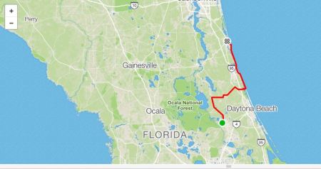
Here’s a link to my Strava track for the day. You can click the picture to get to it.
God bless…
TW
Explore posts in the same categories: Cycling

Leave a comment